HIGHLIGHTS
Kompatibel mit den führenden Scanner-Herstellern wie FARO, Riegl, Topcon, ZF, Velodyne, Stonex, Surestar
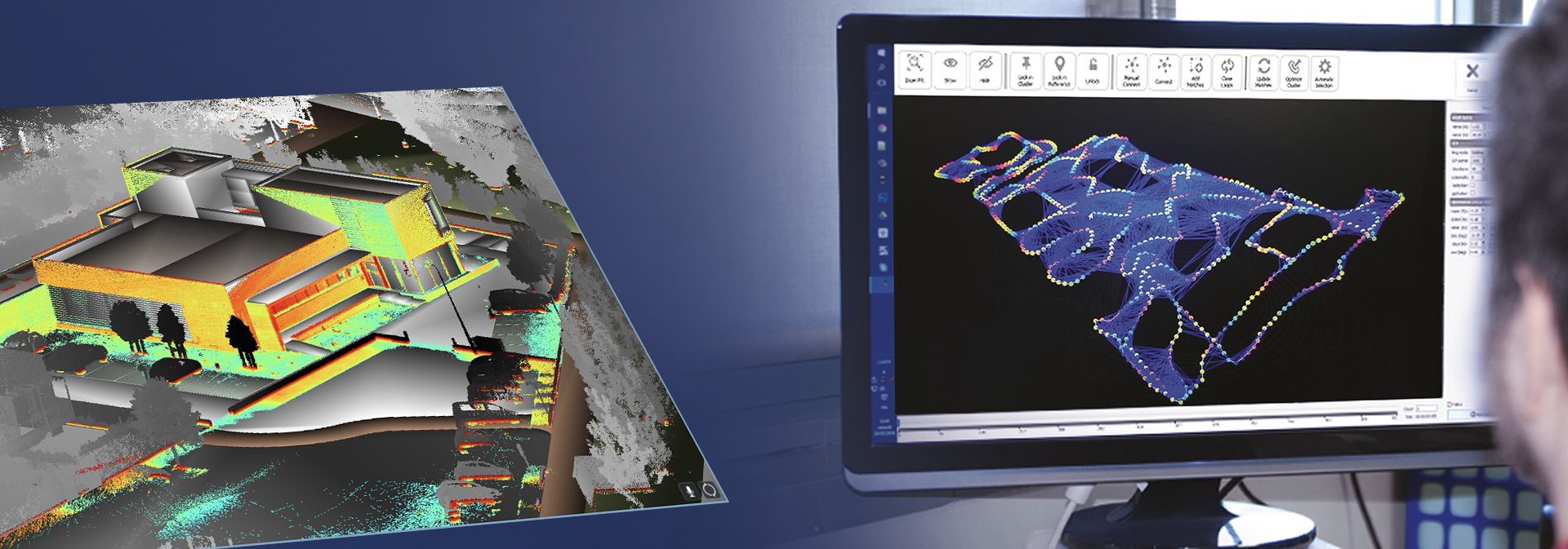
Zielmarkenfreie „Cloud to Cloud“ Registrierung höchster Genauigkeit
Vielfältige Anwendungsgebiete: Construction, Mining-Tunnelling, Heritage-Architectural, Forensic, Foto etc.
Ausgabe aller gängigen Export-Formate (z. B. e57, LAS, pts, ply etc.) und Autodesk ReCap 360 Formate
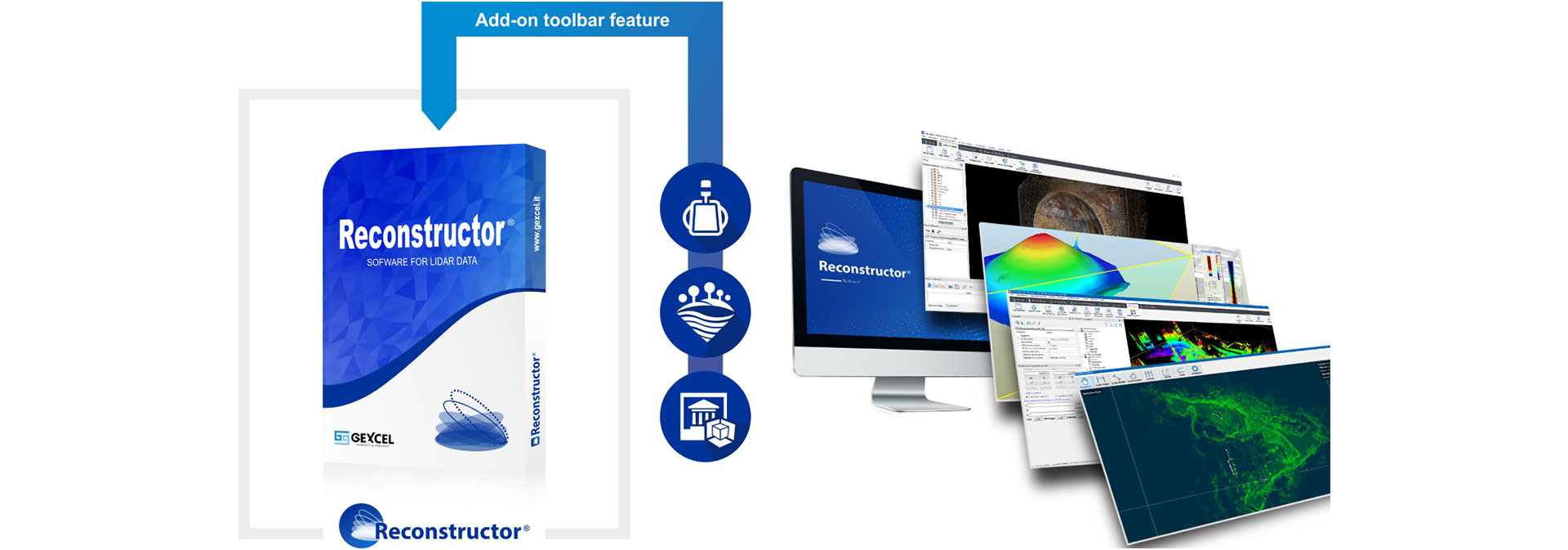
DIE LEISTUNGSSTARKE
3D SCANNING SOFTWARE FÜR LIDAR-DATEN
Wir sind Ihr autorisierter Gexcel-Vertriebspartner für 3D-Laserscanning-Software in Deutschland und Österreich.
Importieren, bearbeiten und verwalten Sie Ihre LiDAR-Daten von terrestrischen, tragbaren, mobilen, luftgestützten Laserscannern und integrieren Sie einfach UAV- und 3D-Bilddaten in einer einzigen Plattform. Dank der LineUp® Pro-Technologie richten Sie Ihre 3D-Scans automatisch aus, auch ohne Zielmarken.

Reconstructor ist kompatibel mit den Punktewolken der gängigen Laserscanner-Hersteller:


ALLE VERSIONEN IM ÜBERBLICK
Kontaktieren Sie uns für ein individuelles Angebot!
|
FEATURES |
Reconstructor |
COLOR |
MINING |
HERON |
|
|
IMPORT |
|||||
|
Import point clouds from open formats |
|
More Details |
|||
|
Import scans in native formats |
|
More Details |
|||
|
Import meshes, CAD/BIM models and polylines |
|
More Details |
|||
|
Import colorization of raw scans |
|
More Details |
|||
|
Import full resolution images or panorama images from scan acquisitions |
|
More Details |
|||
|
Import projects from third parties lidar software |
|
More Details |
|||
|
EXPORT |
|||||
|
Export point clouds in open formats |
|
More Details |
|||
|
Export 3D mesh models in open formats |
|
More Details |
|||
|
ReCap™ Pro connection (import/export) with Gexcel ReCap Plug-in |
|
More Details |
|||
|
POINT CLOUD FILTERING & EDITING |
|||||
|
Point clouds noise removal |
|
More Details |
|||
|
Point clouds normal calculation |
|
More Details |
|||
|
Point clouds quality assessment |
|
More Details |
|||
|
Point clouds editing and clustering |
|
More Details |
|||
|
Point clouds skeleton |
|
More Details |
|||
|
Point clouds manual classification |
|
More Details |
|||
|
Vegetation removal |
|
More Details |
|||
|
3D MODELS REGISTRATION |
|||||
|
LineUp® - Automatic clouds registration |
|
More Details |
|||
|
LineUp® - Automatic cloud to mesh registration |
|
More Details |
|||
|
Registration based on target and spheres |
|
More Details |
|||
|
Cloud to cloud ICP registration |
|
More Details |
|||
|
Multiple scans bundle adjustment |
|
More Details |
|||
|
Georeferencing of models |
|
More Details |
|||
|
Manual registration of models |
|
More Details |
|||
|
MESHING & SHAPES |
|||||
|
Multi-resolution mesh |
|
More Details |
|||
|
View dependent mesh |
|
More Details |
|||
|
Topographic mesh |
|
More Details |
|||
|
3D Mesh |
|
More Details |
|||
|
Mesh editor and simplification |
|
More Details |
|||
|
Mesh border automatic extraction |
|
More Details |
|||
|
Smart polyline drawing |
|
More Details |
|||
|
Fitting of primitives to the point cloud |
|
More Details |
|||
|
Distances and intersections between primitives |
|
More Details |
|||
|
COLORING |
|||||
|
Point colour editor |
|
More Details |
|||
|
Scan layer from external images |
|
More Details |
|||
|
Colour layer cloud segmentation |
|
More Details |
|||
|
Perspective, orthographic and spherical cameras calibration |
|
More Details |
|||
|
Real-time image projection on 3D models |
|
More Details |
|||
|
Texture meshing with calibrated cameras |
|
More Details |
|||
|
GeoTIFF import and projection |
|
More Details |
|||
|
ANALYSIS TOOLS |
|||||
|
Virtual scan |
|
More Details |
|||
|
Unfold cylindrical/spherical surfaces |
|
More Details |
|||
|
Video recording |
|
More Details |
|||
|
Inspection, planarity and verticality maps |
|
More Details |
|||
|
Tunnelling tools |
|
More Details |
|||
|
3DF Zephyr models import |
|
More Details |
|||
|
3DF Zephyr direct connection |
|
More Details |
|||
|
HERON DEDICATED TOOLS |
|||||
|
Blueprint navigation and managing |
|
More Details |
|||
|
HERON® georeferencing |
|
More Details |
|||
|
Send scans to HERON® Desktop |
|
More Details |
|||
|
Reference maps for HERON® tracking |
|
More Details |
|||
|
Export to Orbit GT software |
|
More Details |
|||
|
RESULTS AND OUTPUT |
|||||
|
Point clouds registration report |
|
More Details |
|||
|
Aligned clouds in open formats and ReCap |
|
More Details |
|||
|
Mesh models in open formats |
|
More Details |
|||
|
3D Distances |
|
More Details |
|||
|
Area calculation |
|
More Details |
|||
|
Cross sections and isolines |
|
More Details |
|||
|
Mesh borders and edges extraction |
|
More Details |
|||
|
Volume calculation (with .pdf report) |
|
More Details |
|||
|
Cut & Fill volume (with .pdf report) |
|
More Details |
|||
|
Crests & Toes as polylines |
|
More Details |
|||
|
Orthophotos from point clouds and meshes |
|
More Details |
|||
|
Orthophotos from hi-res textured meshes |
|
More Details |
|||
|
X-Ray orthophotos from point clouds and meshes |
|
More Details |
|||
|
Models change detection (with .pdf report) |
|
More Details |
|||
|
Planarity and verticality maps (with .pdf report) |
|
More Details |
|||
|
Internal camera calibrations |
|
More Details |
|||
|
External camera calibrations |
|
More Details |
|||
|
Videos in standard formats |
|
More Details |
HIGHLIGHTS EDGEWISE
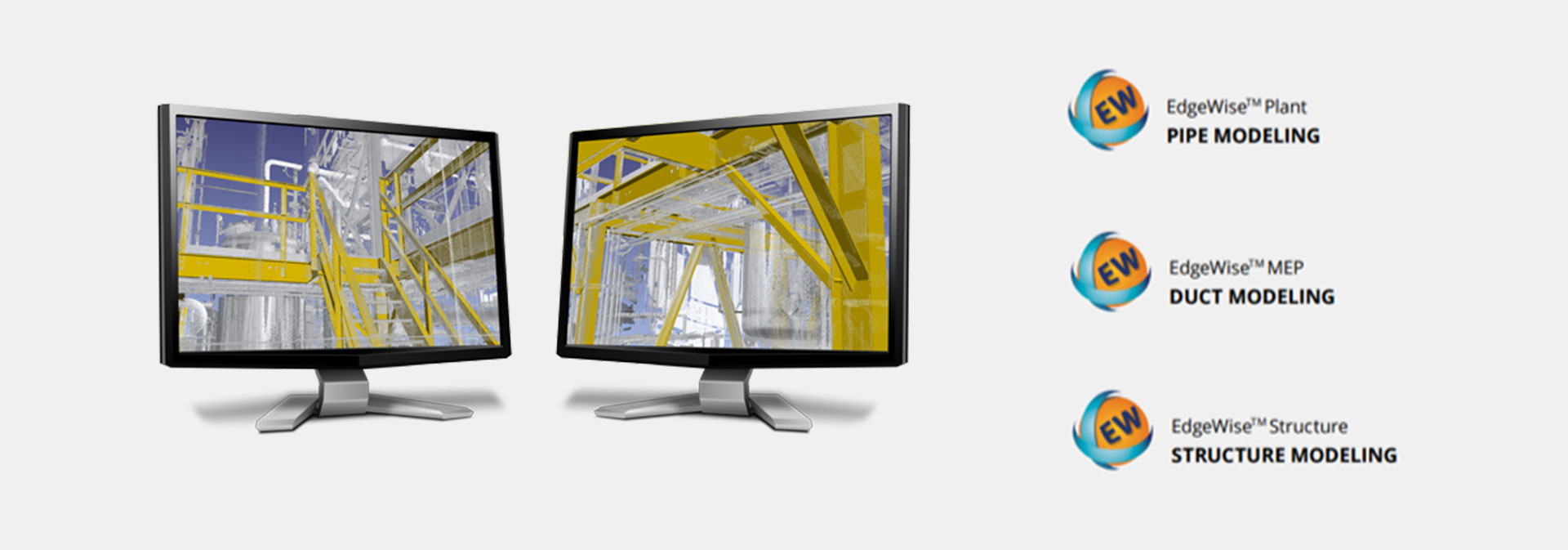
Identifizierung klassischer Geometrien wie z. B. Rohre, Stahlträger, Betonstrukturen, Wände
Fähigkeit, BIM und CAD Modelle automatisch aus der Punktewolke zu extrahieren
Bis zu 70% Zeitersparnis gegenüber dem manuellen Modellieren
Erhältlich optimiert und zugeschnitten auf Ihre jeweilige Aufgabenstellung als Plant, Structure, MEP oder Building Variante.
Für Powernutzer im Architekturbereich gibt es die BIM Suite (Building, MEP, Structure) und für den Industriebereich die Plant Suite (Plant, Structure, incl. integration PDMS, CADWorxs)
Schnittstellen zu Autodesk Produkten wie Autocad, Revit, Plant3D sowie im Fall der EdgeWise Building Lösung mit direkte Plug-In für Revit.
SCHNELLE UND GENAUE
"AS-BUILT" BIM- & CAD-MODELLE
Wir sind Ihr autorisierter Gexcel-Vertriebspartner für 3D-Laserscanning-Software in Deutschland und Österreich.
Entwickelt, um Features aus Punktwolken automatisch zu extrahieren. EdgeWise™-Benutzer bestätigen eine durchschnittliche Einsparung von 70% beim Modellieren. Da Modelle, die von EdgeWise erstellt und nach Autodesk® Revit® als Wand-, Boden-, Rohr-, Kanal-, Kabelkanal-, Fenster- oder Türmodule exportiert wurden auch fehlerfrei von Revit ® als solche erkannt werden, entfällt jegliche Nacharbeit!
UNSER RÜCKRUF-SERVICE:
Hinterlassen Sie einfach Ihre Kontaktdaten
Sie haben Fragen zu unseren Leistungen oder Produkten? Wir rufen Sie gerne zurück! Natürlich können Sie uns jederzeit auch gerne direkt kontaktieren: