HIGHLIGHTS
Compatible with leading scanner manufacturers such as Faro, RIEGL, Topcon, ZF, Velodyne, Stonex, Surestar
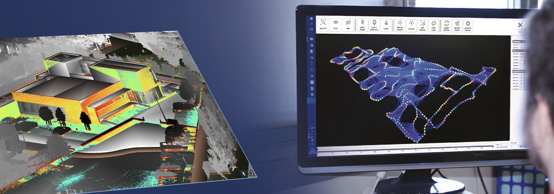
Free of target markers "cloud to cloud" registration of highest accuracy
Various application areas: construction, mining tunnelling, heritage-architectural, forensic, photo etc.
Output of all common export formats (e.g. E57, LAS, pts, ply etc.) and Autodesk Recap 360 formats
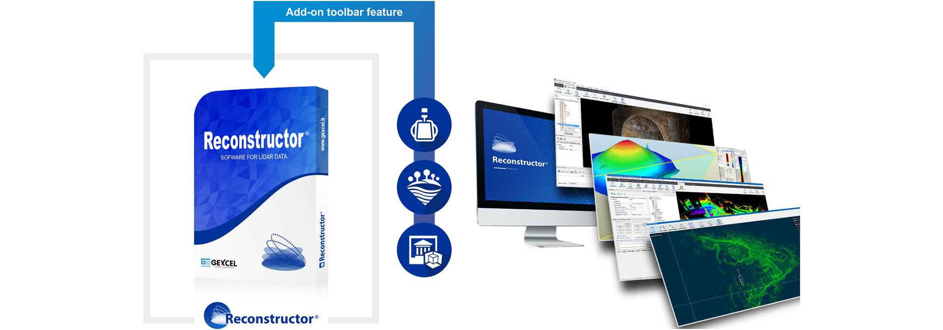
THE POWERFUL
SOFTWARE FOR LIDAR DATA

We are your authorized Gexcel sales partner for 3D laser scanning software in Germany and Austria.
Import, edit and manage your LiDAR data from terrestrial, portable, mobile, air-based laser scanners and easily integrate UAV and 3D image data into a single platform. With Lineup ® Pro technology, you can automatically adjust your 3D scans, even without target markers.

Reconstructor is compatible with the point clouds of the current laser scanner manufacturers:


OVERVIEW - ALL VERSIONS
Contact us for an individual offer
|
FEATURES |
Reconstructor |
COLOR |
MINING |
HERON |
|
|
IMPORT |
|||||
|
Import point clouds from open formats |
|
More Details |
|||
|
Import scans in native formats |
|
More Details |
|||
|
Import meshes, CAD/BIM models and polylines |
|
More Details |
|||
|
Import colorization of raw scans |
|
More Details |
|||
|
Import full resolution images or panorama images from scan acquisitions |
|
More Details |
|||
|
Import projects from third parties lidar software |
|
More Details |
|||
|
EXPORT |
|||||
|
Export point clouds in open formats |
|
More Details |
|||
|
Export 3D mesh models in open formats |
|
More Details |
|||
|
ReCap™ Pro connection (import/export) with Gexcel ReCap Plug-in |
|
More Details |
|||
|
POINT CLOUD FILTERING & EDITING |
|||||
|
Point clouds noise removal |
|
More Details |
|||
|
Point clouds normal calculation |
|
More Details |
|||
|
Point clouds quality assessment |
|
More Details |
|||
|
Point clouds editing and clustering |
|
More Details |
|||
|
Point clouds skeleton |
|
More Details |
|||
|
Point clouds manual classification |
|
More Details |
|||
|
Vegetation removal |
|
More Details |
|||
|
3D MODELS REGISTRATION |
|||||
|
LineUp® - Automatic clouds registration |
|
More Details |
|||
|
LineUp® - Automatic cloud to mesh registration |
|
More Details |
|||
|
Registration based on target and spheres |
|
More Details |
|||
|
Cloud to cloud ICP registration |
|
More Details |
|||
|
Multiple scans bundle adjustment |
|
More Details |
|||
|
Georeferencing of models |
|
More Details |
|||
|
Manual registration of models |
|
More Details |
|||
|
MESHING & SHAPES |
|||||
|
Multi-resolution mesh |
|
More Details |
|||
|
View dependent mesh |
|
More Details |
|||
|
Topographic mesh |
|
More Details |
|||
|
3D Mesh |
|
More Details |
|||
|
Mesh editor and simplification |
|
More Details |
|||
|
Mesh border automatic extraction |
|
More Details |
|||
|
Smart polyline drawing |
|
More Details |
|||
|
Fitting of primitives to the point cloud |
|
More Details |
|||
|
Distances and intersections between primitives |
|
More Details |
|||
|
COLORING |
|||||
|
Point colour editor |
|
More Details |
|||
|
Scan layer from external images |
|
More Details |
|||
|
Colour layer cloud segmentation |
|
More Details |
|||
|
Perspective, orthographic and spherical cameras calibration |
|
More Details |
|||
|
Real-time image projection on 3D models |
|
More Details |
|||
|
Texture meshing with calibrated cameras |
|
More Details |
|||
|
GeoTIFF import and projection |
|
More Details |
|||
|
ANALYSIS TOOLS |
|||||
|
Virtual scan |
|
More Details |
|||
|
Unfold cylindrical/spherical surfaces |
|
More Details |
|||
|
Video recording |
|
More Details |
|||
|
Inspection, planarity and verticality maps |
|
More Details |
|||
|
Tunnelling tools |
|
More Details |
|||
|
3DF Zephyr models import |
|
More Details |
|||
|
3DF Zephyr direct connection |
|
More Details |
|||
|
HERON DEDICATED TOOLS |
|||||
|
Blueprint navigation and managing |
|
More Details |
|||
|
HERON® georeferencing |
|
More Details |
|||
|
Send scans to HERON® Desktop |
|
More Details |
|||
|
Reference maps for HERON® tracking |
|
More Details |
|||
|
Export to Orbit GT software |
|
More Details |
|||
|
RESULTS AND OUTPUT |
|||||
|
Point clouds registration report |
|
More Details |
|||
|
Aligned clouds in open formats and ReCap |
|
More Details |
|||
|
Mesh models in open formats |
|
More Details |
|||
|
3D Distances |
|
More Details |
|||
|
Area calculation |
|
More Details |
|||
|
Cross sections and isolines |
|
More Details |
|||
|
Mesh borders and edges extraction |
|
More Details |
|||
|
Volume calculation (with .pdf report) |
|
More Details |
|||
|
Cut & Fill volume (with .pdf report) |
|
More Details |
|||
|
Crests & Toes as polylines |
|
More Details |
|||
|
Orthophotos from point clouds and meshes |
|
More Details |
|||
|
Orthophotos from hi-res textured meshes |
|
More Details |
|||
|
X-Ray orthophotos from point clouds and meshes |
|
More Details |
|||
|
Models change detection (with .pdf report) |
|
More Details |
|||
|
Planarity and verticality maps (with .pdf report) |
|
More Details |
|||
|
Internal camera calibrations |
|
More Details |
|||
|
External camera calibrations |
|
More Details |
|||
|
Videos in standard formats |
|
More Details |
HIGHLIGHTS EDGEWISE
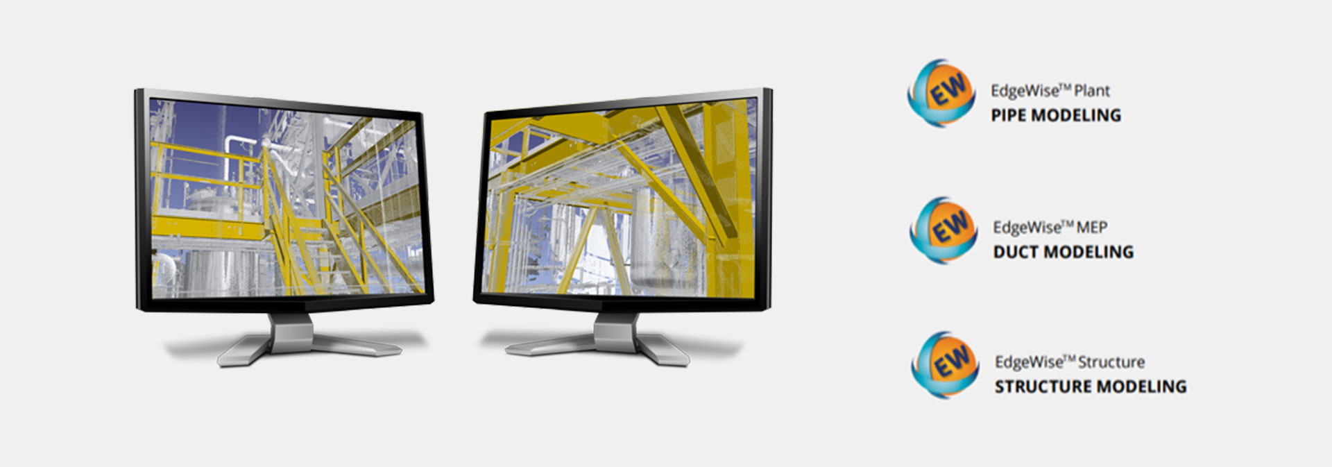
Identification of classical geometries such as pipes, steel girders, concrete structures, walls
Ability to automatically extract BIM and CAD models from the point cloud
Up to 70% time savings compared to manual modeling
Available optimized and tailored to your particular task as plant, structure, MEP or building variant.
For power users in the architectural sector, there is the BIM Suite (building, MEP, structure) and for the industrial sector the Plant Suite (plant, structure, incl. integration PDMS, CADWORXS)
interfaces to Autodesk products such as AutoCAD, Revit, Plant3D and for EdgeWise building solution with direct plug-in for Revit.
FAST AND ACCURATE
"AS-BUILT" BIM & CAD MODELS
We are your authorized Gexcel sales partner for 3d laser scanning software in Germany and Austria.
Designed to automatically extract features from point clouds. EdgeWise ™ users confirm an average time saving of 70% in modeling. Because models created by EdgeWise and exported to Autodesk ® Revit ® as wall, floor, pipe, channel, cable duct, window, or door modules are also recognized as such without error, no rework is necessary!
OUR CALL-BACK SERVICE:
Just leave your contact details
Do you have any questions about our services or products? We will be happy to call you back! Of course you can also contact us directly at any time: